
Physical AI Series · Cross-Industry
Ouster Deep Dive: Digital LiDAR, Spatial Perception, and the 3D Sensing Layer of Physical AI
A business and investor deep dive on Ouster, the digital LiDAR company building 3D sensing hardware and software for autonomy, robotics, smart infrastructure, mapping, security, warehouses, ports, and industrial intelligence.
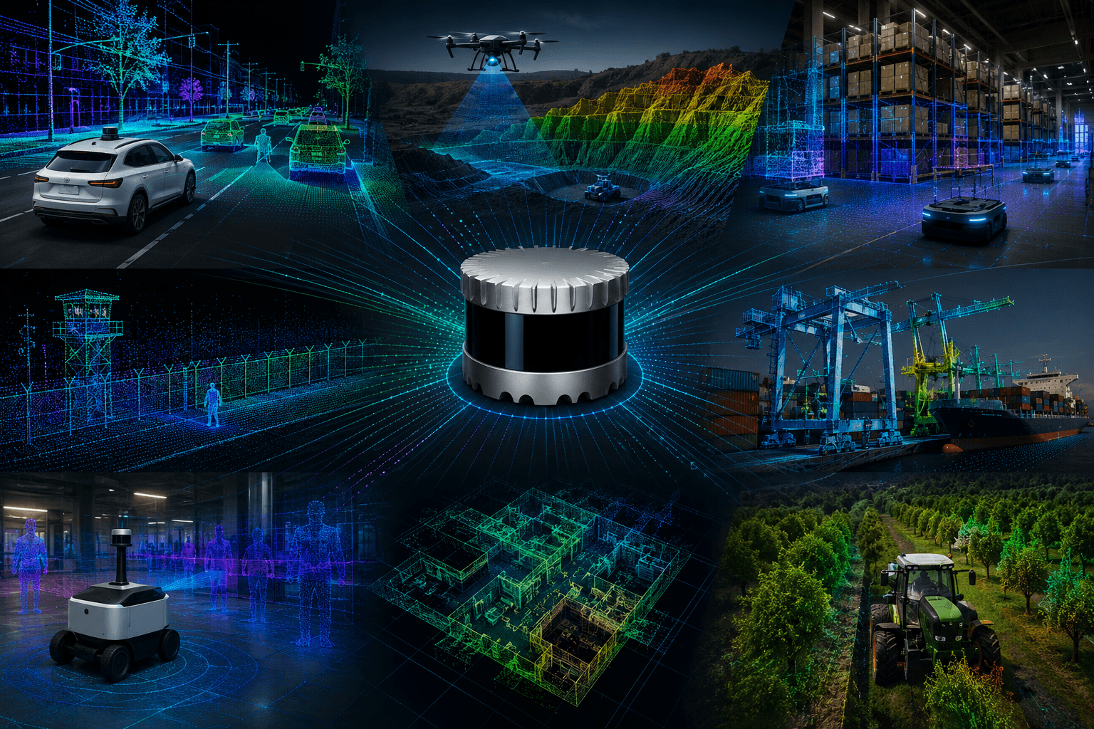
Ouster belongs in the physical AI infrastructure map because LiDAR remains one of the core sensing modalities for machines that need spatial awareness. Cameras are powerful, but LiDAR provides direct range data that can be valuable for mapping, navigation, obstacle detection, smart infrastructure, autonomy, security, and industrial monitoring.
This deep dive is part of Black Scarab's Top 15 Physical AI Infrastructure Companies series, which maps the infrastructure layers behind physical AI: compute, robot intelligence, perception, safety, deployment software, and field data.
The nearest perception and field-data articles are Stereolabs ZED spatial perception, Prophesee's event-based vision layer, and OpenSpace's construction reality-capture layer because LiDAR is one route to spatial ground truth, but not the only way machines and operators make physical environments measurable.
The company is especially interesting because LiDAR demand is not limited to passenger vehicles. The broader physical AI market includes robots, drones, ports, warehouses, security systems, traffic monitoring, mining, agriculture, facility mapping, and machines that need to understand geometry in messy environments.
Ouster's opportunity is to become a sensor infrastructure company across autonomy and industrial intelligence. The more machines need to localize, map, avoid, count, measure, monitor, and operate in shared spaces, the more valuable reliable 3D sensing becomes.
The challenge is market timing and price pressure. LiDAR has gone through hype cycles before, especially in automotive. The stronger case for Ouster may come from diversified physical AI deployments where LiDAR is selected because it solves a specific geometry problem, not because it is attached to a broad autonomous-driving narrative.
Executive Summary
Ouster builds digital LiDAR sensors and software for autonomy, robotics, industrial, smart infrastructure, and mapping applications. Its OS sensor family is designed to provide 3D point-cloud data across short, mid, and long-range deployments, while its software products such as BlueCity and Gemini extend the company from sensor hardware into traffic, safety, security, and spatial analytics.
The company matters because physical AI needs geometry. A computer vision model can recognize that a pallet, vehicle, person, wall, machine, or tree exists. LiDAR helps answer where it is in 3D space, how far away it is, whether something can pass around it, whether a zone is occupied, how an asset moved, and how the environment changed over time.
Ouster's strategic pitch is broader than automotive autonomy. The same sensor architecture can support robots in warehouses, traffic systems at intersections, perimeter security, port automation, mining, drone mapping, agriculture, industrial safety, and facility digitization. That diversification makes the company more interesting than the older LiDAR story that depended almost entirely on passenger-car timelines.
For investors, Ouster is a test of whether 3D sensing becomes a durable physical AI layer. The bull case is that LiDAR becomes a standard spatial sensor across machines and infrastructure. The bear case is that cameras, radar, cheaper depth sensors, embedded perception, and customer price pressure limit the number of applications that can justify dedicated LiDAR.
Ouster at a Glance
What is it?
Practical Answer
A public digital LiDAR company building 3D sensing hardware and software for autonomy, robotics, smart infrastructure, industrial, security, and mapping markets.
What layer does it target?
Practical Answer
The spatial perception layer: direct range data, 3D point clouds, mapping, localization, detection, counting, monitoring, and scene understanding.
Why does it matter?
Practical Answer
Physical AI needs machines to understand space, not only recognize objects in images. LiDAR adds geometry, distance, and measurement.
What is the product shape?
Practical Answer
OS digital LiDAR sensors, REV sensor architecture, BlueCity smart infrastructure software, Gemini security and monitoring software, and developer tools.
What is the core risk?
Practical Answer
LiDAR adoption depends on cost, reliability, software integration, customer timing, and whether specific applications value geometry enough to pay for it.
| Question | Practical Answer |
|---|---|
| What is it? | A public digital LiDAR company building 3D sensing hardware and software for autonomy, robotics, smart infrastructure, industrial, security, and mapping markets. |
| What layer does it target? | The spatial perception layer: direct range data, 3D point clouds, mapping, localization, detection, counting, monitoring, and scene understanding. |
| Why does it matter? | Physical AI needs machines to understand space, not only recognize objects in images. LiDAR adds geometry, distance, and measurement. |
| What is the product shape? | OS digital LiDAR sensors, REV sensor architecture, BlueCity smart infrastructure software, Gemini security and monitoring software, and developer tools. |
| What is the core risk? | LiDAR adoption depends on cost, reliability, software integration, customer timing, and whether specific applications value geometry enough to pay for it. |
Black Scarab Weekly
Follow the physical AI economy
Get Black Scarab news, deep research, and practical analysis in one clear Thursday briefing.
Why LiDAR Still Matters
The easiest mistake is to treat LiDAR as yesterday's autonomous-vehicle story. The technology became famous through self-driving cars, but the need for direct 3D measurement is much broader than passenger autonomy.
Physical AI systems do not only need to know what something is. They need to know where it is, how far away it is, whether it is moving, whether a robot can pass, whether a zone is occupied, whether a structure changed, whether a truck is aligned, whether a person crossed a safety boundary, or whether a machine has enough clearance.
Cameras can infer depth, and stereo cameras can estimate geometry. Radar can provide robust range and velocity. Time-of-flight and structured-light sensors can solve close-range problems. But LiDAR has a distinct role because it creates direct spatial measurements that can be valuable in large, outdoor, industrial, or safety-sensitive environments.
That does not make LiDAR universal. It makes it a tool with a specific job: turn physical space into measurable 3D data. Ouster's future depends on how many markets decide that job is valuable enough to standardize around.
LiDAR's Physical AI Role
Navigation
Why LiDAR Helps
Robots, vehicles, and drones can use 3D range data for obstacle detection, localization, and path planning.
Mapping
Why LiDAR Helps
Point clouds can build or update spatial models of roads, warehouses, ports, mines, facilities, and construction sites.
Monitoring
Why LiDAR Helps
Infrastructure systems can count, classify, track, and measure activity without relying only on camera imagery.
Safety
Why LiDAR Helps
LiDAR can define zones, detect occupancy, and support machine behavior around people, vehicles, and assets.
Measurement
Why LiDAR Helps
Direct range data supports clearance, volume, asset position, geometry change, and spatial analytics.
| Need | Why LiDAR Helps |
|---|---|
| Navigation | Robots, vehicles, and drones can use 3D range data for obstacle detection, localization, and path planning. |
| Mapping | Point clouds can build or update spatial models of roads, warehouses, ports, mines, facilities, and construction sites. |
| Monitoring | Infrastructure systems can count, classify, track, and measure activity without relying only on camera imagery. |
| Safety | LiDAR can define zones, detect occupancy, and support machine behavior around people, vehicles, and assets. |
| Measurement | Direct range data supports clearance, volume, asset position, geometry change, and spatial analytics. |
The Digital LiDAR Thesis
Ouster's identity is built around digital LiDAR. The company has argued for a sensor architecture that can improve through semiconductor integration, software, firmware, and manufacturing scale rather than relying only on complex analog or mechanical designs.
That matters because LiDAR's historic challenge has been cost and reliability. A sensor can be technically impressive and still lose if it is too expensive, fragile, hard to integrate, or tied to a market that takes longer than expected to materialize. Digital architecture is Ouster's answer to that problem.
The OS sensor family gives Ouster a range of deployment profiles, from shorter-range perception to longer-range autonomy and mapping. The product strategy is not to make one sensor for one end market. It is to create a platform that can fit vehicles, robots, infrastructure, security systems, industrial sites, and mapping workflows.
The harder part is proving that platform economics improve with scale. If Ouster can drive down cost, increase reliability, simplify integration, and keep improving performance across product generations, it can make LiDAR feel less like exotic autonomy hardware and more like standard sensing infrastructure.
Ouster Product Stack
Digital LiDAR sensors
Examples
OS0, OS1, OS2, and newer REV-generation sensor products.
Strategic Role
Capture 3D spatial data across different range, field-of-view, and deployment needs.
Sensor data and firmware
Examples
Point clouds, signal processing, firmware, and sensor configuration.
Strategic Role
Turn raw laser returns into usable perception data for autonomy, mapping, and monitoring.
Developer tools
Examples
SDKs, visualization, integration, and data workflows.
Strategic Role
Help customers connect Ouster sensors to robotics, mapping, analytics, and infrastructure applications.
Smart infrastructure software
Examples
BlueCity.
Strategic Role
Use LiDAR to analyze traffic, intersections, road safety, and public infrastructure without relying only on cameras.
Security and monitoring software
Examples
Gemini.
Strategic Role
Use 3D LiDAR for perimeter monitoring, intrusion detection, occupancy, and spatial awareness.
| Layer | Examples | Strategic Role |
|---|---|---|
| Digital LiDAR sensors | OS0, OS1, OS2, and newer REV-generation sensor products. | Capture 3D spatial data across different range, field-of-view, and deployment needs. |
| Sensor data and firmware | Point clouds, signal processing, firmware, and sensor configuration. | Turn raw laser returns into usable perception data for autonomy, mapping, and monitoring. |
| Developer tools | SDKs, visualization, integration, and data workflows. | Help customers connect Ouster sensors to robotics, mapping, analytics, and infrastructure applications. |
| Smart infrastructure software | BlueCity. | Use LiDAR to analyze traffic, intersections, road safety, and public infrastructure without relying only on cameras. |
| Security and monitoring software | Gemini. | Use 3D LiDAR for perimeter monitoring, intrusion detection, occupancy, and spatial awareness. |
From Automotive Hype to Diversified Demand
LiDAR's reputation has been shaped by automotive autonomy. That created enormous excitement, but it also created a timing problem. Passenger-car adoption cycles are slow, safety validation is difficult, and production programs can slip for years. Many LiDAR companies were valued as if robotaxis and advanced autonomy would scale faster than they did.
Ouster's stronger argument is diversification. A traffic intersection can use LiDAR without waiting for fully autonomous passenger cars. A warehouse robot can use LiDAR without solving every edge case of public-road driving. A port, mine, security perimeter, or mapping team can adopt 3D sensing because a local geometry problem is worth solving now.
That shift matters for physical AI. The broadest opportunity may not be one giant automotive program. It may be hundreds of narrower deployments where LiDAR makes a machine or site more aware: counting vehicles, monitoring lanes, localizing a robot, detecting obstacles, mapping a facility, tracking yard activity, or measuring clearance.
The investor question is whether those markets add up fast enough. Diversification can reduce dependence on automotive timing, but it also means Ouster must support different customers, procurement paths, software integrations, and price expectations.
Smart Infrastructure
Smart infrastructure is one of the clearest non-automotive wedges for Ouster. Roads, intersections, bridges, ports, airports, campuses, industrial yards, and logistics sites all need better ways to understand movement in physical space.
Ouster's BlueCity software is aimed at traffic and road safety applications. The core idea is that LiDAR can monitor intersections, detect road users, count movement, analyze near misses, and support traffic management without the same privacy profile as camera-only systems.
This is important because city and infrastructure buyers do not necessarily need a robot. They need situational awareness. They want to understand how vehicles, pedestrians, cyclists, buses, trucks, and equipment move through shared spaces. LiDAR turns that movement into measurable 3D events.
The long-term opportunity is not only sensors on poles. It is a spatial operating layer for infrastructure. If intersections, ports, warehouses, and campuses become instrumented with 3D sensing, software can manage safety, flow, utilization, and risk with far more context than manual observation or 2D video alone.
Smart Infrastructure Use Cases
Traffic monitoring
Why 3D Sensing Helps
Count, classify, and track road users through intersections and corridors.
Road safety analytics
Why 3D Sensing Helps
Measure near misses, conflicts, movement patterns, and dangerous behaviors.
Ports and yards
Why 3D Sensing Helps
Track vehicles, containers, equipment, and restricted zones in large outdoor sites.
Airports and campuses
Why 3D Sensing Helps
Monitor movement, occupancy, access, and safety zones without relying only on cameras.
Security perimeters
Why 3D Sensing Helps
Detect people and vehicles in 3D space across fences, gates, yards, and critical assets.
| Use Case | Why 3D Sensing Helps |
|---|---|
| Traffic monitoring | Count, classify, and track road users through intersections and corridors. |
| Road safety analytics | Measure near misses, conflicts, movement patterns, and dangerous behaviors. |
| Ports and yards | Track vehicles, containers, equipment, and restricted zones in large outdoor sites. |
| Airports and campuses | Monitor movement, occupancy, access, and safety zones without relying only on cameras. |
| Security perimeters | Detect people and vehicles in 3D space across fences, gates, yards, and critical assets. |
Robotics and Autonomy
Robotics is a natural market for Ouster because robots need spatial awareness. Mobile robots, autonomous forklifts, drones, agricultural machines, construction robots, mining equipment, and delivery platforms all need to understand where they are and what surrounds them.
LiDAR can help with mapping, localization, obstacle detection, and navigation. It can also support safety behaviors around people and vehicles. In structured spaces, cameras may be enough. In larger or more variable environments, direct range data can reduce uncertainty.
Ouster's challenge is that robotics buyers are often cost-sensitive. A warehouse robot, outdoor rover, or drone has a bill of materials target. If a cheaper sensor stack can solve the problem, the customer will not pay for LiDAR out of principle. Ouster has to win where geometry, range, reliability, or environmental conditions make the sensor necessary.
The opportunity is that robotics deployments are multiplying across categories. Not every robot needs a long-range LiDAR, but many autonomous systems need some form of 3D spatial perception. If Ouster can be the standard choice for difficult or safety-critical environments, it can ride the broader robot adoption curve.
Security, Monitoring, and Gemini
Security and monitoring are underrated physical AI markets. A site may not need a fully autonomous robot to justify 3D sensing. It may need to know if a person crossed a perimeter, if a vehicle entered a restricted area, if a machine moved into a dangerous zone, or if activity occurred after hours.
Ouster's Gemini software is positioned around 3D LiDAR-based detection, monitoring, and security analytics. The appeal is that LiDAR can define spatial zones and detect presence without depending on visible-light imagery alone.
That can matter in low light, privacy-sensitive areas, industrial sites, and outdoor conditions where camera-only monitoring is imperfect. It also creates a different data product: instead of a video feed, the system can generate spatial events, tracks, alerts, and occupancy information.
This market will still require careful execution. Security buyers care about false positives, weather, installation cost, integration with existing systems, and operational trust. The sensor has to become part of the workflow, not another dashboard that someone ignores.
Mapping, Mining, Agriculture, and Industrial Sites
Some of Ouster's most durable markets may be in places where geometry is the product. Mapping, mining, agriculture, construction, logistics, utilities, and industrial inspection all need spatial data to plan, measure, automate, or verify work.
A drone mapping a quarry, a truck operating in a mine, a tractor moving through an orchard, a robot scanning a facility, or a port system monitoring container movement all benefit from spatial awareness. These are not consumer applications. They are business operations where better measurement can translate into productivity, safety, or asset utilization.
LiDAR is especially useful when the environment is large, three-dimensional, or changing. A camera may show the scene, but a point cloud can support measurement, clearance, volume, slope, obstacle, and map updates. In physical AI, that distinction matters because many workflows need quantified space, not only visual inspection.
The question is whether Ouster can package sensors and software in a way that fits each vertical. Mining, agriculture, ports, and construction do not buy technology the same way. A platform company still has to respect the local workflow.
Software Pulls the Sensor Up the Stack
The most important evolution for Ouster is the move from sensor vendor to sensing platform. Selling hardware alone exposes the company to price pressure. Adding software can make the sensor easier to deploy, more valuable to operators, and more connected to the customer workflow.
BlueCity and Gemini are examples of that shift. They do not merely expose point clouds. They turn point clouds into traffic events, safety analytics, intrusion alerts, occupancy, and monitoring functions. That matters because many buyers do not want to build their own LiDAR perception stack from scratch.
This software layer also helps Ouster explain why LiDAR matters to non-technical buyers. A city does not buy point density. It buys safer intersections, better timing, reduced conflicts, and improved traffic intelligence. A facility does not buy a sensor spec. It buys perimeter awareness, fewer blind spots, and more reliable monitoring.
The risk is that software moves Ouster into more complex sales cycles. A pure sensor sale can be straightforward. A software workflow touches integration, support, data retention, policy, operations, and customer-specific requirements. But if the company can execute, software makes the business less dependent on hardware margins alone.
Hardware Vendor vs. Sensing Platform
Sensor hardware
Revenue Logic
Sell LiDAR units into vehicles, robots, infrastructure, mapping, and industrial systems.
Strategic Tradeoff
Scales with shipments but faces price pressure and customer integration burden.
Modules and developer ecosystem
Revenue Logic
Make integration easier through SDKs, tools, reference designs, and partners.
Strategic Tradeoff
Improves adoption but still depends on customers building the application layer.
Application software
Revenue Logic
Package LiDAR into traffic, security, monitoring, and analytics workflows.
Strategic Tradeoff
Can create recurring value but requires deeper customer support and vertical expertise.
Platform data layer
Revenue Logic
Turn 3D sensing into ongoing spatial intelligence across sites and fleets.
Strategic Tradeoff
Potentially stickier, but harder to build and sell across diverse markets.
| Model | Revenue Logic | Strategic Tradeoff |
|---|---|---|
| Sensor hardware | Sell LiDAR units into vehicles, robots, infrastructure, mapping, and industrial systems. | Scales with shipments but faces price pressure and customer integration burden. |
| Modules and developer ecosystem | Make integration easier through SDKs, tools, reference designs, and partners. | Improves adoption but still depends on customers building the application layer. |
| Application software | Package LiDAR into traffic, security, monitoring, and analytics workflows. | Can create recurring value but requires deeper customer support and vertical expertise. |
| Platform data layer | Turn 3D sensing into ongoing spatial intelligence across sites and fleets. | Potentially stickier, but harder to build and sell across diverse markets. |
The Stereolabs Angle
Ouster's reported Stereolabs acquisition is strategically important because it points toward a broader perception platform. LiDAR is powerful, but physical AI increasingly combines sensors. Cameras provide appearance and texture. Stereo provides depth from images. LiDAR provides direct range and point clouds. Software fuses those signals into usable perception.
That matters because the next phase of sensing may not be about one modality defeating another. It may be about choosing the right sensor mix for the environment. A road, robot, warehouse, drone, or security site may combine cameras, LiDAR, radar, IMUs, and edge compute depending on cost, range, lighting, privacy, and safety requirements.
If Ouster can combine digital LiDAR with camera-based spatial AI and perception software, it can move from component supplier toward full-stack spatial intelligence. That would fit the broader physical AI shift: machines do not need sensors in isolation. They need coherent scene understanding.
The execution risk is integration. Acquisitions can expand a story faster than they expand a product. The meaningful signal will be whether combined LiDAR, camera, and software offerings produce practical deployments, not only a larger sensor catalog.
Competitive Landscape
Ouster competes in a sensor market with multiple pressures. Other LiDAR companies compete on range, cost, form factor, automotive qualification, perception software, and production readiness. Camera-based systems compete by using increasingly capable AI models and cheaper hardware. Radar is improving and can be attractive in weather or velocity-sensitive applications. ToF, stereo, and structured-light sensors can solve shorter-range depth problems at lower cost.
The customer does not care about modality purity. The customer cares whether the system works. If a camera-only stack solves the problem, LiDAR may be unnecessary. If radar plus cameras solve the problem, LiDAR has to justify itself. If a cheap depth module works indoors, Ouster may not fit. The strongest LiDAR cases are those where direct range, field of view, reliability, outdoor performance, or measurement quality changes the outcome.
Ouster's advantage is breadth. It can sell into autonomy, industrial, robotics, smart infrastructure, mapping, and security instead of relying on one segment. Its risk is also breadth. Different markets require different channels, certifications, support models, and price points.
The company wins if it can make digital LiDAR feel like an obvious component in many physical AI systems. It loses if LiDAR remains a specialist tool used only where no cheaper sensing architecture can work.
Ouster Competitive Pressure Map
Camera-only perception
Why It Competes
Cameras are cheap, familiar, high resolution, and supported by strong AI tooling.
Ouster's Response
Win where direct range, geometry, lighting robustness, privacy profile, or measurement quality matters.
Radar
Why It Competes
Radar can be robust in weather and strong for velocity-sensitive applications.
Ouster's Response
Win where higher-resolution 3D geometry and spatial detail are required.
Other LiDAR suppliers
Why It Competes
Competitors may target automotive programs, industrial use cases, or low-cost sensing.
Ouster's Response
Compete on digital architecture, product breadth, software, reliability, and diversification.
Stereo and depth cameras
Why It Competes
They can provide depth at lower cost in many close-range applications.
Ouster's Response
Win where range, outdoor performance, geometry, and point-cloud quality justify LiDAR.
Custom OEM sensor stacks
Why It Competes
Large customers may build or integrate their own multimodal perception systems.
Ouster's Response
Become the reliable LiDAR layer inside those stacks rather than trying to own every sensor.
| Alternative | Why It Competes | Ouster's Response |
|---|---|---|
| Camera-only perception | Cameras are cheap, familiar, high resolution, and supported by strong AI tooling. | Win where direct range, geometry, lighting robustness, privacy profile, or measurement quality matters. |
| Radar | Radar can be robust in weather and strong for velocity-sensitive applications. | Win where higher-resolution 3D geometry and spatial detail are required. |
| Other LiDAR suppliers | Competitors may target automotive programs, industrial use cases, or low-cost sensing. | Compete on digital architecture, product breadth, software, reliability, and diversification. |
| Stereo and depth cameras | They can provide depth at lower cost in many close-range applications. | Win where range, outdoor performance, geometry, and point-cloud quality justify LiDAR. |
| Custom OEM sensor stacks | Large customers may build or integrate their own multimodal perception systems. | Become the reliable LiDAR layer inside those stacks rather than trying to own every sensor. |
Business Model and Market Timing
Ouster is a public company, so investors can watch its revenue, gross margin, shipments, guidance, operating expenses, cash position, and customer mix more directly than with many private physical AI startups. That transparency is useful, but it also means the market reacts quickly to timing risk.
The company has benefited from demand across autonomous vehicles, industrial robots, traffic systems, and other applications. Current reporting around its Q4 2025 results highlighted strong year-over-year growth, sensor shipments, and physical AI positioning, while also noting that part of the quarter benefited from a one-time royalty payment.
That nuance matters. The durable question is not whether a single quarter looks good. It is whether Ouster can grow recurring product demand across diversified markets, improve margins, convert software into higher-value offerings, and avoid being trapped in hardware price compression.
LiDAR adoption can be lumpy. A few large customers can move results. Automotive programs can delay. Infrastructure deployments can be slow. Industrial customers can pilot for a long time before scaling. Ouster's upside comes from being early to a market that becomes much larger. The risk is that the market stays useful but smaller, slower, and more price-sensitive than investors hope.
Investor Case
The bull case for Ouster is that physical AI needs a 3D sensing layer, and LiDAR becomes a standard component across autonomy, robotics, infrastructure, mapping, security, and industrial intelligence. In that world, Ouster is not just an automotive supplier. It is a spatial infrastructure company.
The second bull case is software. If BlueCity, Gemini, developer tools, and perception capabilities make LiDAR easier to buy and deploy, Ouster can capture more value than a pure component vendor. Software can also make customer relationships stickier by tying sensors to daily operations.
The third bull case is multimodal perception. If the Stereolabs angle matures into practical LiDAR-camera-software products, Ouster can participate in a broader spatial AI platform rather than only selling laser scanners.
The bear case is that LiDAR remains a valuable but constrained market. Cameras keep improving. Radar keeps improving. Cheaper depth sensors solve enough indoor problems. Automotive programs take longer. Infrastructure budgets move slowly. Customers pressure pricing. Ouster has to prove that the geometry problem is large enough and urgent enough to support a durable public-company growth story.
Ouster: Bull Case vs. Bear Case
Bull case
Argument
LiDAR becomes a standard spatial perception layer for physical AI.
Signal to Watch
More robots, infrastructure systems, mapping platforms, and industrial sites deploy 3D sensing at scale.
Bull case
Argument
Diversification reduces dependence on passenger-vehicle autonomy timing.
Signal to Watch
Revenue grows across smart infrastructure, industrial, robotics, security, and mapping rather than one narrow segment.
Bull case
Argument
Software products increase value per deployment.
Signal to Watch
BlueCity, Gemini, and perception software become meaningful parts of customer workflows.
Bear case
Argument
LiDAR remains useful but too price-sensitive and application-specific.
Signal to Watch
Customers choose cheaper camera, radar, stereo, ToF, or hybrid stacks when direct LiDAR is not essential.
Execution risk
Argument
The company must scale hardware, software, and vertical sales at the same time.
Signal to Watch
Watch gross margins, customer concentration, product revenue quality, software adoption, and shipment mix.
| View | Argument | Signal to Watch |
|---|---|---|
| Bull case | LiDAR becomes a standard spatial perception layer for physical AI. | More robots, infrastructure systems, mapping platforms, and industrial sites deploy 3D sensing at scale. |
| Bull case | Diversification reduces dependence on passenger-vehicle autonomy timing. | Revenue grows across smart infrastructure, industrial, robotics, security, and mapping rather than one narrow segment. |
| Bull case | Software products increase value per deployment. | BlueCity, Gemini, and perception software become meaningful parts of customer workflows. |
| Bear case | LiDAR remains useful but too price-sensitive and application-specific. | Customers choose cheaper camera, radar, stereo, ToF, or hybrid stacks when direct LiDAR is not essential. |
| Execution risk | The company must scale hardware, software, and vertical sales at the same time. | Watch gross margins, customer concentration, product revenue quality, software adoption, and shipment mix. |
What to Watch Next
First, watch the mix of demand. The strongest Ouster story is diversified adoption across automotive, smart infrastructure, industrial, robotics, security, and mapping. If growth depends too heavily on one market, timing risk rises.
Second, watch BlueCity and Gemini. Software can turn LiDAR from a component into a solution. The important signal is whether those products become operational tools for cities, traffic agencies, facilities, and security teams.
Third, watch margin and pricing. LiDAR has to become affordable enough for volume deployment while still supporting a healthy business. That balance is one of the core tests for the whole sector.
Fourth, watch multimodal sensing. The future may combine LiDAR, cameras, stereo, radar, and edge AI. Ouster's ability to fit into that mixed sensor stack will matter more than arguing that LiDAR replaces every other modality.
Fifth, watch public-market discipline. Ouster is one of the few public physical AI sensor companies with enough visibility to serve as a read-through for the category. Revenue quality, gross margin, operating leverage, and customer adoption will matter as much as technical announcements.
The Bottom Line
Ouster matters because physical AI needs machines and infrastructure to understand space. That means distance, geometry, movement, clearance, occupancy, mapping, and safety. LiDAR is one of the cleanest ways to produce that kind of data.
The company is most compelling when it is not framed as a self-driving-car lottery ticket. The better frame is spatial infrastructure: sensors and software that help robots, roads, ports, warehouses, farms, mines, security systems, and industrial sites perceive the 3D world.
The opportunity is large, but it is not automatic. Ouster has to prove that digital LiDAR can scale across many physical AI markets, that software can pull the business above hardware pricing pressure, and that customers will pay for geometry when the real world gets too complex for cheaper sensors alone.
Sourcing & Verification
This guide was compiled using Ouster's official site, OS sensor materials, BlueCity and Gemini product materials, public investor-relations context, current reporting on Ouster's 2025 results and physical AI positioning, and Black Scarab analysis of LiDAR, smart infrastructure, robotics perception, mapping, security, industrial monitoring, and physical AI deployment economics. Ouster is a public company, so investors should verify current financials, risk factors, guidance, customer concentration, and margins through Ouster's latest SEC filings and investor materials before making any investment decision.
Black Scarab Weekly
Follow the physical AI economy
Get Black Scarab news, deep research, and practical analysis in one clear Thursday briefing.
Related Insights
Cross-Industry
The Best Way to Source GPU Compute in 2026
Compute Exchange Deep Dive: How its marketplace helps organizations source reserved GPU capacity and future commitments, and how it compares with hyperscalers, specialist GPU clouds, and direct deals.
Read related insight
Cross-Industry
Hailo Deep Dive: Edge AI Acceleration, Low-Power Inference, and the Physical AI Compute Layer
A business and investor deep dive on Hailo, the edge AI processor company behind Hailo-8, Hailo-8L, Hailo-10H, Hailo-15, and the Hailo AI Software Suite, showing why efficient local inference is becoming a core deployment layer for physical AI.
Read related insight
Cross-Industry
Prophesee Deep Dive: Event-Based Vision, Neuromorphic Cameras, and the Motion Layer of Physical AI
A business and investor deep dive on Prophesee, the event-based vision company behind Metavision sensors, SDKs, and Mantara, showing why sparse visual events can become a specialist perception layer for robotics, automotive, industrial automation, AR devices, and high-speed monitoring.
Read related insight